| Hale River | |
|---|---|
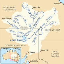
 Map of the Lake Eyre Basin showing Hale River | |
| Location | |
| Country | Australia |
| Territory | Northern Territory |
| Physical characteristics | |
| Source | Mount Laughlen |
| • coordinates | 23°16′23″S 134°14′12″E / 23.27306°S 134.23667°E |
| • elevation | 748 m (2,454 ft)[1] |
| Mouth | Finke River |
• coordinates | 24°43′20″S 135°45′32″E / 24.72222°S 135.75889°E |
• elevation | 189 m (620 ft)[1] |
| Length | 380 km (240 mi)[2] |
| Basin features | |
| River system | Lake Eyre Basin |
The Hale River is a river in the southeast of Australia's Northern Territory. Most of the year, however, it has no water.
It is alternatively known as Lhere Altera or Arletherre to the eastern Arrernte people, who are the traditional owners of much of the country it flows through.[3][4]
- ^ a b Map of Hale River, NT Bonzle.com
- ^ Steve Parish: Australian Touring Atlas. Steve Parish Publishing, Archerfield QLD 2007. ISBN 978-1-74193-232-4. S. 101
- ^ "Ruby Gap & Glen Annie Gorge | Tourism Central Australia". www.discovercentralaustralia.com. Retrieved 27 May 2024.
- ^ "Ruby Gap Nature Park Joint Management Plan March 2021". Darwin: Legislative Assembly of the Northern Territory. Retrieved 27 May 2024.