Hallingdal | |
|---|---|
 Frå Hallingdal (Joachim Frich) | |
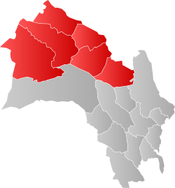
 Map of Hallingdal and municipalities within Viken County | |
| Coordinates: 60°38′N 9°3′E / 60.633°N 9.050°E | |
| Country | Norway |
| County | Buskerud |
| Region | Austlandet |
| Adm. Center | Nesbyen |
| Area | |
• Total | 5,830 km2 (2,250 sq mi) |
| Population (2014) | |
• Total | 20,569 |
| • Density | 3.5/km2 (9.1/sq mi) |
| Demonym(s) | Halling Hallingdøl is used by many outside the valley.[1] |
Hallingdal (English: Halling Valley)[2][3][4] is a valley as well as a traditional district located in the traditional and electoral district Buskerud county in Norway. It consists of six municipalities: Flå, Nes, Gol, Hemsedal, Ål and Hol.[5]
Hallingdal is one of the major valleys of eastern Norway, on an area of 5,830 square kilometers. Hallingdal lies in the northern part of the county of Buskerud. The valley stretches from Gulsvik by Lake Krøderen to the border with Hordaland and Sogn og Fjordane. Central to the geography is relatively flat mountain area which lies 700–1,100 m (2,300–3,600 ft) above sea level. The valley is V-shaped and is drained by the Hallingdal River which originates in the western parts of Hardangervidda and flows eastwards later southwards through Hallingdal.[6][7]
- ^ Sylfest Lomheim (5 August 2015). "Dølar på Dalen". Klassekampen. p. 10.
- ^ North Dakota, a Guide to the Northern Prairie State. 1938. Fargo, ND: Knight Printing Company, p. 79.
- ^ Middleton, William D. 2000. Yet There Isn't a Train I Wouldn't Take. Bloomington: Indiana University Press, p. 114.
- ^ Berman, Martha. 1993. Fielding's Scandinavia. New York: Fielding Travel Books, p. 298.
- ^ Thorsnæs, Geir (April 2019). "Hallingdal". snl.no.
- ^ Rosvold, Knut A. (29 December 2013). "Hallingdalsvassdraget". snl.no.
- ^ "Om Hallingdal (Regionrådet for Hallingdal)". Archived from the original on 17 February 2015.

