Halsa Municipality
Halsa kommune | |
|---|---|
| Halse herred (historic name) | |
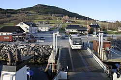
 Ferry quay in Halsanaustan | |
|
| |
 Møre og Romsdal within Norway | |
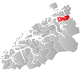
 Halsa within Møre og Romsdal | |
| Coordinates: 63°06′50″N 08°28′13″E / 63.11389°N 8.47028°E | |
| Country | Norway |
| County | Møre og Romsdal |
| District | Nordmøre |
| Established | 1 Jan 1838 |
| • Created as | Formannskapsdistrikt |
| Disestablished | 1 Jan 2020 |
| • Succeeded by | Heim Municipality |
| Administrative centre | Liabøen |
| Government | |
| • Mayor (2007-2019) | Ola Rognskog (Sp) |
| Area (upon dissolution) | |
• Total | 300.53 km2 (116.04 sq mi) |
| • Land | 292.29 km2 (112.85 sq mi) |
| • Water | 8.24 km2 (3.18 sq mi) 2.7% |
| • Rank | #279 in Norway |
| Population (2018) | |
• Total | 1,571 |
| • Rank | #349 in Norway |
| • Density | 5.4/km2 (14/sq mi) |
| • Change (10 years) | |
| Demonym | Halsabygg[1] |
| Official language | |
| • Norwegian form | Neutral |
| Time zone | UTC+01:00 (CET) |
| • Summer (DST) | UTC+02:00 (CEST) |
| ISO 3166 code | NO-1571[3] |
Halsa is a former municipality in Møre og Romsdal county, Norway. The municipality existed from 1838 until 2020 when it became part of Heim Municipality in Trondelag county. It was part of the Nordmøre region. The administrative centre of Halsa was the village of Liabøen. Other villages in the municipality included Todalen, Halsanaustan, Valsøyfjord, Engan, Hjellnes, and Valsøybotnen.
At the time of its dissolution in 2020, the 301-square-kilometre (116 sq mi) municipality was the 279th largest by area out of the 422 municipalities in Norway. Halsa was the 349th most populous municipality in Norway with a population of 1,571. The municipality's population density was 5.4 inhabitants per square kilometre (14/sq mi) and its population has decreased by 6% over the last decade.[4][5]
- ^ "Navn på steder og personer: Innbyggjarnamn" (in Norwegian). Språkrådet.
- ^ "Forskrift om målvedtak i kommunar og fylkeskommunar" (in Norwegian). Lovdata.no.
- ^ Bolstad, Erik; Thorsnæs, Geir, eds. (26 January 2023). "Kommunenummer". Store norske leksikon (in Norwegian). Kunnskapsforlaget.
- ^ Statistisk sentralbyrå (2018). "Table: 06913: Population 1 January and population changes during the calendar year (M)" (in Norwegian). Retrieved 13 April 2019.
- ^ Statistisk sentralbyrå. "09280: Area of land and fresh water (km²) (M)" (in Norwegian). Retrieved 13 April 2019.

