Hamirpur district | |
|---|---|
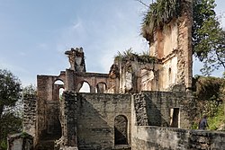
Top: Katoch Palace, Tira Sujanpur Bottom: view of mountains from Rangar village | |
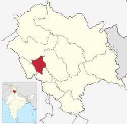
 Location in Himachal Pradesh | |
| Coordinates (Hamirpur): 31.6798° N, 76.5026° E | |
| Country | |
| State | |
| Division | Mandi[1] |
| Established | 1972 |
| Headquarters | Hamirpur |
| Tehsils | 5+2(Sub-Tehsils)[2] |
| Government | |
| • Lok Sabha Constituency | Hamirpur |
| • Lok Sabha Member | Anurag Singh Thakur[3] |
| • Vidhan Sabha constituencies | Barsar, Hamirpur, Sujanpur, Nadaun, Bhoranj. |
| Area | |
• Total | 1,118 km2 (432 sq mi) |
| Population (2011) | |
• Total | 454,768 |
| • Density | 410/km2 (1,100/sq mi) |
| Demographics | |
| • Literacy | 90% |
| Time zone | UTC+05:30 (IST) |
| Vehicle registration | HP-22 |
| Website | http://hphamirpur.nic.in/ |
Hamirpur district is in the Indian state of Himachal Pradesh. The headquarters of the district are in the town of Hamirpur. With an area of 1,118 square kilometres or 432 square miles, it is the smallest district of Himachal Pradesh.


