Hampden | |
|---|---|
Rural settlement | |
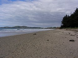
 The beach at Hampden looking south | |
 | |
| Coordinates: 45°19′40″S 170°49′00″E / 45.32778°S 170.81667°E | |
| Country | New Zealand |
| Region | Otago |
| Territorial authority | Waitaki District |
| Ward | Waihemo Ward |
| Community | Waihemo Community |
| Electorates |
|
| Government | |
| • Territorial authority | Waitaki District Council |
| • Regional council | Otago Regional Council |
| • Mayor of Waitaki | Gary Kircher |
| • Waitaki MP | Miles Anderson |
| • Te Tai Tonga MP | Tākuta Ferris |
| Area | |
• Total | 2.56 km2 (0.99 sq mi) |
| Population (June 2024)[2] | |
• Total | 380 |
| • Density | 150/km2 (380/sq mi) |
| Time zone | UTC+12 (New Zealand Standard Time) |
| • Summer (DST) | UTC+13 (New Zealand Daylight Time) |
| Postcode | 9410 |
Hampden, a small town[3] in North Otago, New Zealand, lies close to the North Otago coast, 35 kilometres south of Oamaru and 80 kilometres north of the city of Dunedin, to both of which it is connected by State Highway 1.
The township's population at its largest was about 560, but by 2009 it had dwindled to approximately 230.[4] Hampden is named in honour of the English politician John Hampden by early surveyor W. B. D. Mantell, possibly influenced by the location of a public house, The Hampden Hotel, at the site.[5]
- ^ Cite error: The named reference
Areawas invoked but never defined (see the help page). - ^ "Aotearoa Data Explorer". Statistics New Zealand. Retrieved 26 October 2024.
- ^ "Place name detail: Hampden". New Zealand Gazetteer. New Zealand Geographic Board. Retrieved 29 May 2007.
- ^ Rae, S. "Hampden set to mark 130 years as township," Otago Daily Times, 22 October 2009. Retrieved 20 April 2018.
- ^ Reed, A.W. (1975) Place names of New Zealand. Wellington: A.H. & A.W. Reed. p.159