Hampton, Maryland | |
|---|---|
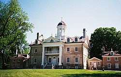
 The Hampton National Historic Site in Hampton, Maryland | |
 Location of Hampton in the State of Maryland | |
| Coordinates: 39°25′22″N 76°35′5″W / 39.42278°N 76.58472°W | |
| Country | |
| State | |
| County | |
| Area | |
| • Total | 6.35 sq mi (16.45 km2) |
| • Land | 5.95 sq mi (15.41 km2) |
| • Water | 0.40 sq mi (1.04 km2) |
| Elevation | 338 ft (103 m) |
| Population (2020) | |
| • Total | 5,180 |
| • Density | 870.44/sq mi (336.08/km2) |
| Time zone | UTC-5 (Eastern (EST)) |
| • Summer (DST) | UTC-4 (EDT) |
| ZIP codes | 21286, 21093 [2] |
| Area code | 410 / 443 |
| FIPS code | 24-36512 |
| GNIS feature ID | 0590409 |
Hampton is an unincorporated community and census-designated place (CDP) in Baltimore County, Maryland, United States. The population was 5,052 at the 2010 census.[3] Hampton is often considered a subdivision of the nearby community of Towson and is located just north of Baltimore, about twenty minutes from downtown. Hampton contains residences situated on lots up to several acres in a park-like setting (current zoning limits density to not more than two residential units per acre). The community is anchored by its principal landmark, the Hampton National Historic Site. The Towson United Methodist Church is located in Hampton, flanked on the south by I-695 and Goucher College.
- ^ "2020 U.S. Gazetteer Files". United States Census Bureau. Retrieved April 26, 2022.
- ^ "Hampton Maryland ZIP Code Map". Zipdatamaps.
- ^ "Profile of General Population and Housing Characteristics: 2010 Demographic Profile Data (DP-1): Hampton CDP, Maryland". United States Census Bureau. Retrieved February 23, 2012.