Hancock, Massachusetts | |
|---|---|
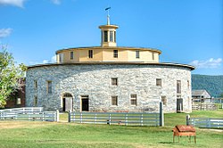
 The Round Barn at Hancock Shaker Village | |
 Location in Berkshire County and the state of Massachusetts. | |
| Coordinates: 42°32′35″N 73°19′27″W / 42.54306°N 73.32417°W | |
| Country | United States |
| State | Massachusetts |
| County | Berkshire |
| Settled | 1767 |
| Incorporated | 1776 |
| Government | |
| • Type | Open town meeting |
| Area | |
• Total | 35.8 sq mi (92.6 km2) |
| • Land | 35.7 sq mi (92.4 km2) |
| • Water | 0.08 sq mi (0.2 km2) |
| Elevation | 1,058 ft (322 m) |
| Population (2020) | |
• Total | 757 |
| • Density | 21/sq mi (8.2/km2) |
| Time zone | UTC-5 (Eastern) |
| • Summer (DST) | UTC-4 (Eastern) |
| ZIP code | 01237 (Lanesborough), 01267 (Williamstown), 01201 (Pittsfield) |
| Area code | 413 |
| FIPS code | 25-28180 |
| GNIS feature ID | 0619421 |
| Website | town.hancock.ma.us |
Hancock is a town in Berkshire County, Massachusetts, United States. It is part of the Pittsfield, Massachusetts Metropolitan Statistical Area. The population was 757 at the 2020 census.[1]
- ^ "Census – Geography Profile: Hancock town, Berkshire County, Massachusetts". United States Census Bureau. Retrieved November 14, 2021.

