| Hartest | |
|---|---|
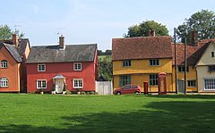
 Bright cottages lining the green at Hartest | |
Location within Suffolk | |
| Population | 446 {2011}[1] |
| OS grid reference | TL834524 |
| District | |
| Shire county | |
| Region | |
| Country | England |
| Sovereign state | United Kingdom |
| Post town | BURY ST EDMUNDS |
| Postcode district | IP29 |
| Dialling code | 01284 |
| Police | Suffolk |
| Fire | Suffolk |
| Ambulance | East of England |
| UK Parliament | |
Hartest is a small village and civil parish in the Babergh district of the English county of Suffolk. It is located halfway between Bury St. Edmunds and Sudbury on the B1066 road in the Glem valley. Brockley is two miles north.
The village of Hartest dates back to before 1086 and features in the Domesday Book.[2] The name 'Hartest' is thought to mean either 'Stag Hill' or 'Stag Wood'.[3] It is claimed that there are no other villages, towns or cities in the world of the same name.[4]
The village is centred on the large village green, fringed by an array of brightly coloured cottages, the village hall or institute, the medieval All Saints church and the Crown public house, formerly Hartest Hall the local landowner's seat. There is an annual fete held on the village green at the end of August each year.[5]
Running east of the village centre is Hartest Hill, the steepest in Suffolk.[6]
Former Special Envoy for the Archbishop of Canterbury and Islamic Jihad Organization hostage, Terry Waite lives in the village.[7]
- ^ "Parish population 2011". Retrieved 12 September 2015.
- ^ "Place: Hartest". domesdaymap.co.uk/. Open Domesday. Archived from the original on 3 November 2014. Retrieved 3 November 2014.
- ^ "Parish: Hartest" (PDF). suffolk.gov. Suffolk County Council. Retrieved 3 November 2014.
- ^ "Hartest". onesuffolk.net. OneSuffolk. Retrieved 3 November 2014.
- ^ "Hartest.onesuffolk news and events".
- ^ "Hartest Hill - Hartest, Suffolk". climbbybike.com. Climb By Bike. Retrieved 3 November 2014.
- ^ "Terry Waite returning to Beirut". BBC. 16 February 2004. Retrieved 16 December 2010.
