Hartland, Connecticut | |
|---|---|
| Town of Hartland | |
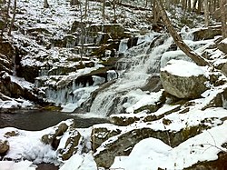
 Falls Brook in the Tunxis State Forest | |
| Coordinates: 42°00′18″N 72°56′53″W / 42.00500°N 72.94806°W | |
| Country | |
| U.S. state | |
| County | Hartford |
| Region | Northwest Hills |
| Settled | 1754 |
| Incorporated | 1761 |
| Villages | East Hartland West Hartland |
| Government | |
| • Type | Selectman-town meeting |
| • First Selectman | Magi Winslow (D) |
| • Selectman | Scott M. Levan (R) |
| • Selectman | Gregory M. Sottile (D) |
| Area | |
• Total | 34.6 sq mi (89.6 km2) |
| • Land | 33.1 sq mi (85.7 km2) |
| • Water | 1.5 sq mi (3.9 km2) |
| Elevation | 531 ft (162 m) |
| Population (2020)[1] | |
• Total | 1,901 |
| • Density | 55/sq mi (21/km2) |
| Time zone | UTC-5 (Eastern) |
| • Summer (DST) | UTC-4 (Eastern) |
| ZIP Codes | 06027, 06091 |
| Area code(s) | 860/959 |
| FIPS code | 09-37140 |
| GNIS feature ID | 0213443[1] |
| Website | www |
Hartland is a town in Hartford County, Connecticut, United States. The population was 1,901 at the 2020 census.[2] The rural town is part of the Northwest Hills Planning Region and forms the northwestern border of Hartford County. Currently, the town consists of two unincorporated areas, East and West Hartland, entirely separated by the northern portion of the Barkhamsted Reservoir. A third area, Hartland Hollow (also referred to as Hartland Center), was flooded when the reservoir was completed in 1940.


