Hartsel, Colorado | |
|---|---|
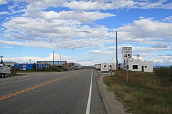
 U.S. Route 24/State Highway 9 in Hartsel, September 2006 | |
Location of the Hartsel CDP in the State of Colorado. | |
| Coordinates: 39°01′19″N 105°47′52″W / 39.02194°N 105.79778°W[1] | |
| Country | |
| State | |
| County | Park County |
| Founded | 1880 |
| Government | |
| • Type | unincorporated town |
| Area | |
| • Total | 0.192 sq mi (0.498 km2) |
| • Land | 0.188 sq mi (0.486 km2) |
| • Water | 0.005 sq mi (0.012 km2) |
| Elevation | 8,904 ft (2,714 m) |
| Population | |
| • Total | 38 |
| Time zone | UTC-7 (MST) |
| • Summer (DST) | UTC-6 (MDT) |
| ZIP Code[4] | 80449 |
| Area code | 719 |
| GNIS feature ID | 2805924[1] |
Hartsel is a census-designated place (CDP) in and governed by Park County, Colorado United States. The population was 38 at the 2020 census.[3] The Hartsel post office has the ZIP Code 80449.[4] The CDP is a part of the Denver–Aurora–Lakewood, CO Metropolitan Statistical Area.
- ^ a b c U.S. Geological Survey Geographic Names Information System: Hartsel, Colorado
- ^ "State of Colorado Census Designated Places - BAS20 - Data as of January 1, 2020". United States Census Bureau. Retrieved December 26, 2020.
- ^ a b United States Census Bureau. "Hartsel CDP, Colorado". Retrieved April 9, 2023.
- ^ a b "Look Up a ZIP Code". United States Postal Service. Retrieved December 26, 2020.
