Hatiya
হাতিয়া | |
|---|---|
| Hatiya | |
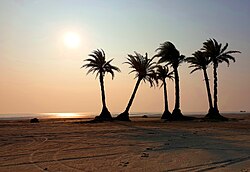
 Sunset on Nijhum Dwip, south of Hatiya Island | |
 | |
| Coordinates: 22°22′N 91°7.5′E / 22.367°N 91.1250°E | |
| Country | |
| Division | Chittagong |
| District | Noakhali |
| Government | |
| • MP (Noakhali-6) | Ayesha Ferdaus |
| • Upazila Chairman | Mahbub Murshid Liton |
| Area | |
• Upazila | 1,507.35 km2 (581.99 sq mi) |
| • Metro | 888.035 km2 (342.872 sq mi) |
| Population | |
• Upazila | 537,366 |
| • Density | 360/km2 (920/sq mi) |
| Time zone | UTC+6 (BST) |
| Postal code | 3890[2] |
| Area code | 03224[3] |
| Website | hatia |
Hatiya (Bengali: হাতিয়া) is an upazila (sub-district) of Noakhali District in Bangladesh's Chittagong Division.[4] It encompasses several islands of Bangladesh, most notably Hatiya Island, Bhasan Char, Nijhum Dwip and Jahazir Char.[5]
- ^ National Report (PDF). Population and Housing Census 2022. Vol. 1. Dhaka: Bangladesh Bureau of Statistics. November 2023. p. 397. ISBN 978-9844752016.
- ^ "Bangladesh Postal Code". Dhaka: Bangladesh Postal Department under the Department of Posts and Telecommunications of the Ministry of Posts, Telecommunications and Information Technology of the People's Republic of Bangladesh. 20 October 2024.
- ^ "Bangladesh Area Code". China: Chahaoba.com. 18 October 2024.
- ^ Chowdhury, Muhammad Tawhid Hussain Chowdhury (2012). "Hatiya Upazila". In Sirajul Islam; Miah, Sajahan; Khanam, Mahfuza; Ahmed, Sabbir (eds.). Banglapedia: the National Encyclopedia of Bangladesh (Online ed.). Dhaka, Bangladesh: Banglapedia Trust, Asiatic Society of Bangladesh. ISBN 984-32-0576-6. OCLC 52727562. OL 30677644M. Retrieved 25 November 2024.
- ^ "3 army men killed in Noakhali road accident". Dhaka Tribune. 8 February 2019. Retrieved 9 February 2019.