Hato Rey | |
|---|---|
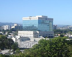
 RG Financial Corporation headquarters in Hato Rey. | |
 Location of Hato Rey shown in yellow. | |
| Coordinates: 18°25′26″N 66°04′59″W / 18.4239°N 66.0831°W | |
| Commonwealth | Puerto Rico |
| Municipality | San Juan |
| Area | |
• Total | 6.18 sq mi (16.01 km2) |
| • Land | 5.38 sq mi (13.93 km2) |
| • Water | 0.80 sq mi (2.07 km2) |
| Population (2000) | |
• Total | 48,196 |
| • Density | 8,958.36/sq mi (3,458.84/km2) |
| 2000 census | |
| ZIP Code | 00917, 00919 |
Hato Rey is a former barrio located in the northwest part of the dissolved municipality of Río Piedras. It now stretches over three barrios of the municipality of San Juan, Puerto Rico: Hato Rey Norte, Hato Rey Central, and Hato Rey Sur.