Nickname: Croatoan Island | |
|---|---|
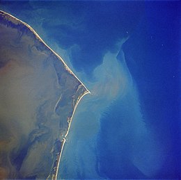
 Hatteras Island as seen in a satellite photo. North is to the upper left corner. | |
| Geography | |
| Location | Atlantic Ocean, Pamlico Sound |
| Area | 85.56 km2 (33.03 sq mi) |
| Length | 68 km (42.3 mi) |
Hatteras Island (historically Croatoan Island, sometimes referred to as Hatorask[1]) is a barrier island located off the North Carolina coast. Dividing the Atlantic Ocean and the Pamlico Sound, it runs parallel to the coast, forming a bend at Cape Hatteras. It is part of North Carolina's Outer Banks and includes the communities of Rodanthe, Waves, Salvo, Avon, Buxton, Frisco, and Hatteras. It contains the largest part of the Cape Hatteras National Seashore. Prior to European settlement the island was inhabited by Croatoan Native Americans.
The island has a land area of 85.56 km2 (33.03 sq mi) and a population of 4,322, as of the 2010 census.[2] It lies in parts of Kinnakeet Township and Hatteras Township in Dare County, and Ocracoke Township in Hyde County. Hatteras Island is known for sport fishing, surfing, windsurfing and kiteboarding, and Hatteras Village is known as the "Blue Marlin Capital of the World".[3]
The island is one of the longest in the contiguous United States, measuring 42 miles (68 km) along a straight line from end to end, or roughly 50 miles (80 km) along the curve of the land.[3] The island, because of its function as a barrier island and its low lying profile, has experienced significant coastal erosion because of sea level rise.[4][5] Some sections have significantly eroded already, with portions of Hatteras Island at 25% of its original [clarification needed] width as of 2014.[5]
- ^ "The Roanoke Colonies". February 28, 2024.
- ^ "Hatteras and Ocracoke gain in 2010 census with the greatest increase in Hispanics". Island Free Press. March 9, 2011. Retrieved October 26, 2020.
- ^ a b "Hatteras Island - OuterBanks.com". www.outerbanks.com. Retrieved October 26, 2020.
- ^ "How the Outer Banks are Vanishing—and Leaving NC Defenseless Against Hurricanes". Carolina Political Review. November 20, 2019. Retrieved November 19, 2020.
- ^ a b Peach, Sara (July 24, 2014). "Rising Seas: Will the Outer Banks Survive?". National Geographic. Archived from the original on August 12, 2019.
