| Hauraki Rift | |
|---|---|
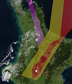
 Intra-arc continental rifts North Island, New Zealand. Purple approximately delineates the active Hauraki Rift, red the active modern Taupō Rift and yellow the inactive old Taupō Rift. | |
| Etymology | Hauraki Gulf |
| Coordinates | 37°15′0″S 175°28′0″E / 37.25000°S 175.46667°E (extends 37°30′S to at least 36°30′S) |
| Country | New Zealand |
| Region | North Island |
| Characteristics | |
| Segments | Multiple |
| Length | 250 km (160 mi)[1] |
| Width | 25 km (16 mi) |
| Displacement | 0.46 mm (0.018 in)/yr[1] |
| Tectonics | |
| Plate | Indo-Australian |
| Status | Active |
| Earthquakes | Mainly tectonic |
| Type | Intra-arc continental rift |
| Movement | Possibly up to Mw7.2-7.4[1] |
| Age | Miocene-Holocene |
| Volcanic arc/belt | Coromandel volcanoes |
| New Zealand geology database (includes faults) | |
The Hauraki Rift is an active NeS-to NWeSE-striking rift valley system in the North Island of New Zealand that has produced the Firth of Thames and the Hauraki Plains. It is approximately 25 kilometres (16 mi) wide and 250 kilometres (160 mi) long.