| Hauser Dam | |
|---|---|
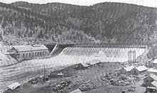
 Hauser Dam in late 1908 during its reconstruction. | |
| Official name | Hauser Dam |
| Location | Lewis and Clark County, Montana, U.S. |
| Coordinates | 46°45′55″N 111°53′13″W / 46.76528°N 111.88694°W |
| Construction began | 1905 (first dam); 1908 (second dam) |
| Opening date | 1907 (first dam); 1911 (second dam) |
| Operator(s) | NorthWestern Corporation |
| Dam and spillways | |
| Impounds | Missouri River |
| Height | 80 feet (24 m) (second dam) |
| Length | 700 feet (210 m) (second dam) |
| Reservoir | |
| Creates | Hauser Lake |
| Normal elevation | 3,655 ft (1,114 m)[1] |
| Power Station | |
| Installed capacity | 17.7 MW[2] |
| Annual generation | 135.34 GWh (2009)[3] |
| Power transmission: 69 kV single-circuit | |
Hauser Dam (also known as Hauser Lake Dam) is a hydroelectric straight gravity dam on the Missouri River about 14 miles (23 km) northeast of Helena, Montana, in the United States. The original dam, built between 1905 and 1907, failed in 1908 and caused severe flooding and damage downstream. A second dam was built on the site in 1908 and opened in 1911 and comprises the present structure. The current Hauser Dam is 700 feet (210 m) long and 80 feet (24 m) high.[4] The reservoir formed by the dam, Hauser Lake (also known as Hauser Reservoir), is 25 miles (40 km) long, has a surface area of 3,800 acres (1,500 ha), and has a storage capacity of 98,000 acre-feet (121,000,000 m3) of water when full.[5]
The dam is a "run-of-the-river" dam because it can generate electricity without needing to store additional water supplies behind the dam. The powerhouse contains six generators, bringing Hauser dam's generating capacity to 17 MW.
- ^ U.S. Geological Survey Geographic Names Information System: Hauser Dam
- ^ "Century of service: Turbines at Hauser Dam to be removed for refurbishing". Independent Record. 4 April 2015. Retrieved 7 November 2016.
- ^ "Hauser". Carbon Monitoring for Action. Retrieved 2018-04-26.
- ^ Upper Missouri River Reservoir Fisheries Management Plan, 2010–2019, Montana Department of Fish, Wildlife and Parks, May 13, 2010, p. 11.
- ^ Upper Missouri River Reservoir Fisheries Management Plan, 2010–2019, Montana Department of Fish, Wildlife and Parks, May 13, 2010, pp. 7, 9.