Haverhill, New Hampshire | |
|---|---|
Town | |
 Haverhill municipal offices | |
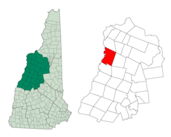
 Location in Grafton County, New Hampshire | |
| Coordinates: 44°02′03″N 72°03′50″W / 44.03417°N 72.06389°W | |
| Country | United States |
| State | New Hampshire |
| County | Grafton |
| Incorporated | 1763 |
| Villages |
|
| Government | |
| • Selectboard |
|
| Area | |
• Total | 52.4 sq mi (135.6 km2) |
| • Land | 51.0 sq mi (132.1 km2) |
| • Water | 1.4 sq mi (3.5 km2) 2.62% |
| Elevation | 640 ft (200 m) |
| Population (2020)[2] | |
• Total | 4,585 |
| • Density | 90/sq mi (34.7/km2) |
| Time zone | UTC-5 (EST) |
| • Summer (DST) | UTC-4 (EDT) |
| ZIP codes | |
| Area code | 603 |
| FIPS code | 33-34820 |
| GNIS feature ID | 0873621 |
| Website | www |
Haverhill is a town and the seat of Grafton County, New Hampshire, United States. The population was 4,585 at the 2020 census.[2] Haverhill includes the villages of Woodsville, Pike, and North Haverhill, the historic town center at Haverhill Corner, and the district of Mountain Lakes. Located here are Bedell Bridge State Park, Black Mountain State Forest, Kinder Memorial Forest, and Oliverian Valley Wildlife Preserve. It is home to the annual North Haverhill Fair, and to a branch of the New Hampshire Community Technical Colleges.
- ^ "2021 U.S. Gazetteer Files – New Hampshire". United States Census Bureau. Retrieved November 29, 2021.
- ^ a b "Haverhill town, Grafton County, New Hampshire: 2020 DEC Redistricting Data (PL 94-171)". U.S. Census Bureau. Retrieved November 29, 2021.
