Nickname: The Big Island, Moku o Keawe | |
|---|---|
 Landsat mosaic, 1999–2001 | |
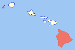
 Location in the state of Hawaii | |
| Geography | |
| Location | North Pacific Ocean |
| Coordinates | 19°36′N 155°30′W / 19.6°N 155.5°W |
| Area | 4,028 sq mi (10,430 km2) |
| Area rank | Largest Hawaiian Island |
| Highest elevation | 13,803 ft (4207.2 m)[1] |
| Highest point | Mauna Kea |
| Administration | |
United States | |
| Symbols | |
| Flower | Red Pua Lehua (ʻOhiʻa blossom) |
| Color | ʻUlaʻula (red) |
| Largest settlement | Hilo |
| Demographics | |
| Population | 200,629 (2020) |
| Pop. density | 49.8/sq mi (19.23/km2) |
| Additional information | |
| Time zone | |
Hawaii (/həˈwaɪ.i/ hə-WY-ee; Hawaiian: Hawaiʻi Hawaiian pronunciation: [həˈvɐjʔi]) is the largest island in the United States, located in the eponymous state of Hawaii. It is the southeasternmost of the Hawaiian Islands, a chain of volcanic islands in the North Pacific Ocean. With an area of 4,028 square miles (10,430 km2), it has 63% of the Hawaiian archipelago's combined landmass. However, it has only 13% of the archipelago's population. The island of Hawaiʻi is the third largest island in Polynesia, behind the north and south islands of New Zealand.[2]
The island is often referred to as the Island of Hawaii or Hawaii Island to distinguish it from the state. It is also referred to as The Big Island, due to its size relative to the other islands. In Hawaiian, the island is sometimes called Moku o Keawe. The word keawe has several meanings. One definition, "southern cross", is said to be the name of an ancient chief.[3] Another definition is "the bearer" (ke-a-we).[4] Hawaii County is the local administrative unit.
As of the 2020 census, the population was 200,629.[5] The county seat and largest town is Hilo. Hawaiʻi County has no incorporated cities.[6]
- ^ "Summit USGS 1977". NGS Data Sheet. National Geodetic Survey, National Oceanic and Atmospheric Administration, United States Department of Commerce. Retrieved August 18, 2010.
- ^ "List of the Islands of Polynesia". Archived from the original on January 1, 2017.
- ^ Mary Māmaka Kaiao Kuleana kope. "Hawaiian Dictionary". University of Hawaii Press. Retrieved July 27, 2017.
- ^ Andrews-Parker. "Nā Puke Wehewehe a Pau (Andrews Dictionary)". University of Hawaii Press. Retrieved July 27, 2017.
- ^ "HAWAII: 2020 Census". United States Census Bureau. Archived from the original on April 4, 2022. Retrieved April 4, 2022.
- ^ "2010 Geographic Terms and Concepts – Place". census.gov. Archived from the original on February 19, 2014.