| Hawthorn East Melbourne, Victoria | |||||||||||||||
|---|---|---|---|---|---|---|---|---|---|---|---|---|---|---|---|
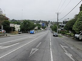
 Toorak Road in Hawthorn East | |||||||||||||||
 | |||||||||||||||
| Coordinates | 37°49′52″S 145°03′00″E / 37.831°S 145.050°E | ||||||||||||||
| Population | 14,834 (2021 census)[1] | ||||||||||||||
| • Density | 3,900/km2 (10,110/sq mi) | ||||||||||||||
| Established | 1880s | ||||||||||||||
| Postcode(s) | 3123 | ||||||||||||||
| Elevation | 52 m (171 ft) | ||||||||||||||
| Area | 3.8 km2 (1.5 sq mi) | ||||||||||||||
| Location | 7 km (4 mi) from Melbourne | ||||||||||||||
| LGA(s) | City of Boroondara | ||||||||||||||
| State electorate(s) | Hawthorn | ||||||||||||||
| Federal division(s) | Kooyong | ||||||||||||||
| |||||||||||||||
Hawthorn East is a suburb of Melbourne, Victoria, Australia, 7 km (4.3 mi) east of the Melbourne central business district, located within the City of Boroondara local government area. Hawthorn East recorded a population of 14,834 at the 2021 census.[1]
The suburb is roughly bounded by Barkers Road to the north, Burke Road to the east, Toorak Road and the Monash Freeway to the south and Auburn Road to the west.
Hawthorn East is the home of a number of head offices for some of Australia's largest companies, including Coles and Bunnings.
- ^ a b Australian Bureau of Statistics (28 June 2022). "Hawthorn East (Suburbs and Localities)". 2021 Census QuickStats. Retrieved 3 July 2022.
