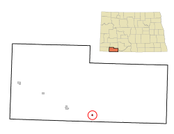
Haynes, North Dakota | |
|---|---|
 Haynes, North Dakota | |
 Location of Haynes, North Dakota | |
| Coordinates: 45°58′26″N 102°28′16″W / 45.97389°N 102.47111°W | |
| Country | United States |
| State | North Dakota |
| County | Adams |
| Founded as Gadsden | 1906 |
| Founded as Haynes | 1907 |
| Area | |
| • Total | 0.14 sq mi (0.35 km2) |
| • Land | 0.14 sq mi (0.35 km2) |
| • Water | 0.00 sq mi (0.00 km2) |
| Elevation | 2,543 ft (775 m) |
| Population | |
| • Total | 15 |
| • Estimate (2022)[4] | 15 |
| • Density | 111.11/sq mi (42.86/km2) |
| Time zone | UTC-7 (Mountain (MST)) |
| • Summer (DST) | UTC-6 (MDT) |
| ZIP code | 58639 |
| Area code | 701 |
| FIPS code | 38-36540 |
| GNIS feature ID | 1036087[2] |
Haynes is a city in Adams County, North Dakota, United States. The population was 15 at the 2020 census.[3]
Haynes was founded as Gadsden in 1906 along the Milwaukee Road's transcontinental rail line known as the Pacific Extension. The name was changed to Haynes in 1907 to honor George B. Haynes, president of the Milwaukee Road at the time.[5]
- ^ "ArcGIS REST Services Directory". United States Census Bureau. Retrieved September 20, 2022.
- ^ a b U.S. Geological Survey Geographic Names Information System: Haynes, North Dakota
- ^ a b "Explore Census Data". United States Census Bureau. Retrieved December 14, 2023.
- ^ Cite error: The named reference
USCensusEst2022was invoked but never defined (see the help page). - ^ Wick, Douglas A. "Haynes (Adams County)". North Dakota Place Names. Retrieved May 7, 2011.