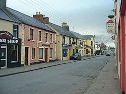
Headford
Irish: Áth Cinn | |
|---|---|
Town | |
 Main Street | |
| Motto: Áth Cinn le Chéile | |
| Coordinates: 53°28′09″N 9°06′25″W / 53.469115°N 9.106849°W | |
| Country | Ireland |
| Province | Connacht |
| County | County Galway |
| Government | |
| • Dáil Éireann | Galway East |
| Population | 1,235 |
| Time zone | UTC+0 (WET) |
| • Summer (DST) | UTC-1 (IST (WEST)) |
| Irish Grid Reference | M269468 |
Headford (Irish: Áth Cinn)[2] is a small town in County Galway, located 26 km north of Galway city in the west of Ireland.[3] It is an angling centre for the eastern shore of Lough Corrib, and Greenfields, approximately 6.5 km west of the town, is its boating harbour. The town is situated next to the Black River (known also for its trout angling) which is the county boundary with Mayo. Located on the N84 national secondary road from Galway to Castlebar and the R333, and R334 regional roads, the town is a commuter town to Galway City.
The town is the centre of an area which contains a number of prehistoric burial cairns, Iron Age stone enclosures, early Norman and later castles, and several monastic sites. These include Ross Errilly Friary, located northwest of Headford, which is one of the best preserved monastic ruins of its period in Ireland.[4]
According to 2022 census, there were 1,235 people living in Headford.[1]
- ^ a b "Profile 1 - Population Distribution and Movement F1015 - Population: Headford, Co. Galway". Central Statistics Office (Ireland). Retrieved 21 July 2023.
- ^ "Headford". logainm.ie. Irish Placenames Database. Retrieved 16 April 2012.
- ^ "6.1 Headford Small Growth Town". Galway County Development Plan 2022-2028. Galway County Council. 2021. Retrieved 6 January 2023.
Headford is located approximately 26km north of Galway City and 20km west of Tuam [..] The town straddles the county boundary with County Mayo and it is strategically located along the National Secondary Road, the N84
- ^ "Ross Errilly Friary". heritage.galwaycommunityheritage.org. Galway County Council Heritage Office.
