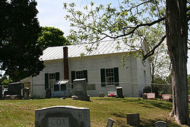
Headsville | |
|---|---|
 Headsville United Methodist Church | |
| Coordinates: 39°23′33″N 78°51′21″W / 39.39250°N 78.85583°W | |
| Country | United States |
| State | West Virginia |
| County | Mineral |
| Elevation | 682 ft (208 m) |
| Time zone | UTC-5 (Eastern (EST)) |
| • Summer (DST) | UTC-4 (EDT) |
| GNIS feature ID | 1554672[1] |
Headsville is an unincorporated community in Mineral County, West Virginia, United States. It is part of the Cumberland, MD-WV Metropolitan Statistical Area. It lies between U.S. Route 50 and West Virginia Route 46 alongside Pattersons Creek.
Fort Cocke of the French and Indian War was located near Headsville.

