| Heaphy Track | |
|---|---|
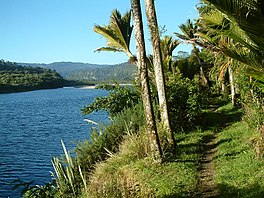
 Along the Heaphy River | |
| Length | 78.4 km (48.7 mi) |
| Location | Kahurangi National Park |
| Designation | New Zealand Great Walks |
| Trailheads |
|
| Use |
|
| Highest point | 915 m (3,002 ft) |
| Lowest point | 0 m (0 ft) |
| Season |
|
| Maintained by | Department of Conservation |
The Heaphy Track is a popular tramping and mountain biking track in the north west of the South Island of New Zealand. It is located within the Kahurangi National Park and classified as one of New Zealand's ten Great Walks by the Department of Conservation. Named after Charles Heaphy, the track is 78.4 kilometres (48.7 mi) long and is usually walked in four or five days. The track is open for shared use with mountain bikers in the winter season from 1 May to 30 September each year. The southern end of the track is at Kōhaihai, north of Karamea on the northern West Coast, and the northern end is in the upper valley of the Aorere River, Golden Bay.
Floods in February 2022 caused major damage to three bridges on the West Coast end of the track, leading to the closure of the section between James Mackay Hut and Heaphy Hut, and preventing walkers and cyclists from completing the full distance. The damaged section of track re-opened in October 2023, after the replacement of bridges and restoration of tracks damaged in the 2022 floods.
