| Heavy Runner Mountain | |
|---|---|
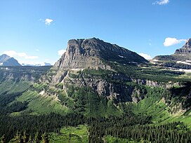
 Heavy Runner Mountain as seen from the Going-to-the-Sun Road | |
| Highest point | |
| Elevation | 8,016 ft (2,443 m)[1] |
| Prominence | 767 ft (234 m)[1] |
| Coordinates | 48°40′36″N 113°41′41″W / 48.67667°N 113.69472°W[2] |
| Geography | |
| Location | Glacier County, Montana, U.S. |
| Parent range | Lewis Range |
| Topo map | USGS Logan Pass MT |
| Climbing | |
| First ascent | Unknown |
| Easiest route | Scramble class 2-3 |
Heavy Runner Mountain (8,016 feet (2,443 m)) is located in the Lewis Range, Glacier National Park in the U.S. state of Montana.[3] The summit is a little over a mile east-northeast of Reynolds Mountain and is easily seen from the Going-to-the-Sun Road as well as Logan Pass. The mountain is named for the Blackfeet Indian Chief, Heavy Runner, who was massacred along with most of his encampment by Col. Eugene M. Baker's detachment on the Marias River on January 23, 1870.[4]
- ^ a b "Heavy Runner Mountain, Montana". Peakbagger.com. Retrieved May 23, 2018.
- ^ "Heavy Runner Mountain". Geographic Names Information System. United States Geological Survey, United States Department of the Interior. Retrieved May 23, 2018.
- ^ Logan Pass, MT (Map). TopoQwest (United States Geological Survey Maps). Retrieved May 23, 2018.
- ^ Through The Years In Glacier National Park An Administrative History, NPS.gov

