| Heber Down Conservation Area | |
|---|---|
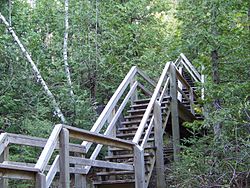
 A stairway descending into Devil's Den gully. | |
 | |
| Location | Canada |
| Nearest city | Whitby, Ontario |
| Coordinates | 43°56′3″N 78°58′56″W / 43.93417°N 78.98222°W |
| Area | 284 ha |
| Governing body | Central Lake Ontario Conservation Authority |
Heber Down Conservation Area is located in Whitby, Ontario and is owned and operated by Central Lake Ontario Conservation Authority. It is located within the Lynde Creek drainage basin; it is a part of the provincially significant Heber Down Wetland Complex.[1] The area is composed of two types of broad terrain units: a valley formed by the creek and the Glacial Lake Iroquois beach.[2] The area provides such recreational activities as hiking, mountain biking, picnicking, and fishing.[3]
- ^ "Heber Down Conservation Area". Ontario Trails Council. Retrieved 2008-05-09.
- ^ "Natural Areas Report: HEBER DOWN CONSERVATION AREA". Ontario Ministry of Natural Resources. 2006-06-05. Archived from the original on 2007-08-02. Retrieved 2008-05-09.
- ^ "Heber Down Conservation Area Brochure" (PDF). Central Lake Ontario Conservation Authority. Archived from the original (PDF) on 2008-05-11. Retrieved 2008-05-09.