You can help expand this article with text translated from the corresponding article in German. (February 2009) Click [show] for important translation instructions.
|
 | |
| Area | 306 km² |
|---|---|
| Classification | Handbook of Natural Region Divisions of Germany |
| Highest point | 867.2 m (2,845 ft) |
| County/District | Konstanz district, Tuttlingen district, Schwarzwald-Baar |
| State(s) | Baden-Württemberg |
| Country | Germany |
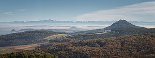
Hegau either refers to a region of the Duchy of Swabia or to only that part of said region which is presently located in the country of Germany. It is known for its extinct, partly eroded volcanoes, most of which are crowned with ruins of medieval fortresses.
Historically, Hegau was a Gau of the Duchy of Swabia, first mentioned in 787 A.D. in the Latinised form in pago Egauinsse.[1] Its area reached from the Überlinger See of Lake Constance and the city of Konstanz in the east to the Randen and Schaffhausen in the present-day Swiss canton of Schaffhausen in the west. Towards south, it extended to the High Rhine and to the north until the Danube.
Today, Hegau refers only to that part of the former Gau which is located within the German state of Baden-Württemberg. This region, also called the Hegauer Kegelbergland (lit. 'Hegau conical hill landscape'), is a Young Drift morainic landscape marked by the remains of several extinct volcanoes, the Hegau volcanoes, which are located mostly to the west and east of the line from Singen (Hohentwiel) in the south to Geisingen in the north. The Hegau volcanoes are national geotopes of Germany.[2]
- ^ Albert Krieger: Topographisches Wörterbuch des Großherzogtums Baden, Vol. 1, p. 882 (1904)
- ^ "Hegau-Vulkane" (in German). LGRBwissen. Retrieved 2 June 2024.