| Helensburgh Sydney, New South Wales | |||||||||||||||
|---|---|---|---|---|---|---|---|---|---|---|---|---|---|---|---|
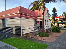
 Helensburgh Post Office | |||||||||||||||
 | |||||||||||||||
| Coordinates | 34°11′26″S 150°58′55″E / 34.19056°S 150.98194°E | ||||||||||||||
| Population | 6,576 (2021 census)[1] | ||||||||||||||
| Established | 1865 | ||||||||||||||
| Postcode(s) | 2508 | ||||||||||||||
| Elevation | 255 m (837 ft) | ||||||||||||||
| Location |
| ||||||||||||||
| LGA(s) | City of Wollongong | ||||||||||||||
| State electorate(s) | Heathcote | ||||||||||||||
| Federal division(s) | Cunningham | ||||||||||||||
| |||||||||||||||
Helensburgh is a small town, located 45 kilometres (28 mi) south of Sydney and 35 kilometres (22 mi) north of Wollongong and north and above the Illawarra escarpment and region. Helensburgh is in the Wollongong City Council local government area. It is surrounded by bushland reserves adjacent to the southern end of the Royal National Park and Garawarra State Conservation Area and the Woronora reservoir water catchment is to its west.
- ^ Australian Bureau of Statistics (28 June 2022). "Helensburgh (State Suburb)". 2021 Census QuickStats. Retrieved 29 July 2024.
