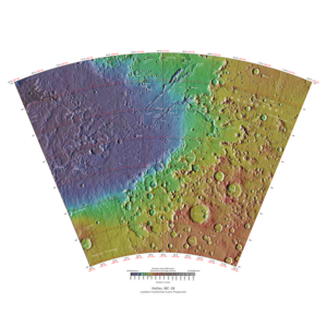
 Map of Hellas quadrangle from Mars Orbiter Laser Altimeter (MOLA) data. The highest elevations are red and the lowest are blue. | |
| Coordinates | 47°30′S 270°00′W / 47.5°S 270°W |
|---|---|

The Hellas quadrangle is one of a series of 30 quadrangle maps of Mars used by the United States Geological Survey (USGS) Astrogeology Research Program. The Hellas quadrangle is also referred to as MC-28 (Mars Chart-28).[1] The Hellas quadrangle covers the area from 240° to 300° west longitude and 30° to 65° south latitude on the planet Mars. Within the Hellas quadrangle lies the classic features Hellas Planitia and Promethei Terra. Many interesting and mysterious features have been discovered in the Hellas quadrangle, including the giant river valleys Dao Vallis, Niger Vallis, Harmakhis, and Reull Vallis—all of which may have contributed water to a lake in the Hellas basin in the distant past.[2][3][4] Many places in the Hellas quadrangle show signs of ice in the ground, especially places with glacier-like flow features.
- ^ Davies, M.E.; Batson, R.M.; Wu, S.S.C. (1992). "Geodesy and Cartography". In Kieffer, H.H.; Jakosky, B.M.; Snyder, C.W.; et al. (eds.). Mars. Tucson: University of Arizona Press. ISBN 978-0-8165-1257-7.
- ^ Carr, Michael H. (2006). The Surface of Mars. Cambridge University Press. p. [page needed]. ISBN 978-0-521-87201-0.
- ^ Moore, J; Wilhelms, Don E. (2001). "Hellas as a possible site of ancient ice-covered lakes on Mars". Icarus. 154 (2): 258–276. Bibcode:2001Icar..154..258M. doi:10.1006/icar.2001.6736. hdl:2060/20020050249. S2CID 122991710.
- ^ Cabrol, N. and E. Grim (eds). 2010. Lakes on Mars