Hellendoorn | |
|---|---|
Town and municipality | |
 Looking toward the Hellendoorn town centre | |
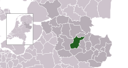
 Location in Overijssel | |
| Coordinates: 52°22′N 6°28′E / 52.367°N 6.467°E | |
| Country | Netherlands |
| Province | Overijssel |
| Government | |
| • Body | Municipal council |
| • Mayor | Jorrit Eijbersen (VVD) |
| Area | |
| • Total | 138.99 km2 (53.66 sq mi) |
| • Land | 137.91 km2 (53.25 sq mi) |
| • Water | 1.08 km2 (0.42 sq mi) |
| Elevation | 10 m (30 ft) |
| Population (January 2021)[4] | |
| • Total | 35,932 |
| • Density | 261/km2 (680/sq mi) |
| Time zone | UTC+1 (CET) |
| • Summer (DST) | UTC+2 (CEST) |
| Postcode | 7440–7449, 7687–7689 |
| Area code | 0546, 0548 |
| Website | www |
Hellendoorn (Dutch pronunciation: [ˌɦɛlə(n)ˈdoːr(ə)n] ; Tweants: Heldern or Healndoorn) is a municipality and town in the middle of the Dutch province of Overijssel. As of 2019, the municipality had a population of 35,808.
There is an amusement park near the town of Hellendoorn called Avonturenpark Hellendoorn. At the outskirts of the town there is an ice cream factory from Unilever, where Ben & Jerry's is produced for the European market.
- ^ "Burgemeester en wethouders" [Mayor and aldermen] (in Dutch). Gemeente Hellendoorn. Archived from the original on 8 April 2014. Retrieved 29 March 2014.
- ^ "Kerncijfers wijken en buurten 2020" [Key figures for neighbourhoods 2020]. StatLine (in Dutch). CBS. 24 July 2020. Retrieved 19 September 2020.
- ^ "Postcodetool for 7442MA". Actueel Hoogtebestand Nederland (in Dutch). Het Waterschapshuis. Archived from the original on 21 September 2013. Retrieved 29 March 2014.
- ^ "Bevolkingsontwikkeling; regio per maand" [Population growth; regions per month]. CBS Statline (in Dutch). CBS. 1 January 2021. Retrieved 2 January 2022.
