| Helmdon | |
|---|---|
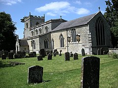
 St Mary Magdalene parish church | |
Location within Northamptonshire | |
| Population | 899 (2011 Census)[1] |
| OS grid reference | SP5843 |
| • London | 72 miles (116 km) |
| Civil parish |
|
| Unitary authority | |
| Ceremonial county | |
| Region | |
| Country | England |
| Sovereign state | United Kingdom |
| Post town | Brackley |
| Postcode district | NN13 |
| Dialling code | 01295 |
| Police | Northamptonshire |
| Fire | Northamptonshire |
| Ambulance | East Midlands |
| UK Parliament | |
| Website | Welcome to Helmdon |
Helmdon is a village and civil parish about 4 miles (6.4 km) north of Brackley in West Northamptonshire, England. The village is on the River Tove, which is flanked by meadows that separate the village into two. The parish includes the hamlets of Astwell and Falcutt and covers more than 1,550 acres (630 ha).[2] The 2011 Census recorded a parish population of 899.[1]
The villages name means 'Helma's valley'. Alternatively, 'Helma (= helmet)' may be the name of a nearby hill. Early spellings also reflect confusion with Old English 'hamol' meaning, 'maimed'.[3]
- ^ a b "Area: Helmdon (Parish); Key Figures for 2011 Census: Key Statistics". Neighbourhood Statistics. Office for National Statistics. Retrieved 21 November 2013.[permanent dead link]
- ^ RCHME 1982, pp. 80–88
- ^ "Key to English Place-names".
