| Helperthorpe | |
|---|---|
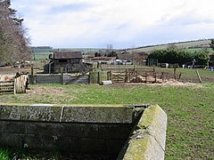
 Looking north-east from the grounds of St Peter's Church | |
Location within North Yorkshire | |
| OS grid reference | SE953703 |
| Civil parish | |
| Unitary authority | |
| Ceremonial county | |
| Region | |
| Country | England |
| Sovereign state | United Kingdom |
| Post town | MALTON |
| Postcode district | YO17 |
| Police | North Yorkshire |
| Fire | North Yorkshire |
| Ambulance | Yorkshire |
| UK Parliament | |
Helperthorpe is a village in the civil parish of Luttons, in North Yorkshire, England. The village lies in the Great Wold Valley and the course of the winterbourne stream the Gypsey Race passes through it.[1]
The village is 10 miles (16 km) north west of Driffield and 10 miles (16 km) east of Malton.[2]
In 1931 the parish had a population of 123.[3] On 1 April 1935 the parish was abolished and merged with Luttons Ambo to form "Luttons",[4] The population of the Luttons at the 2011 census was 411, with an estimated population of 430 in 2015.[5][6]
- ^ "Genuki: HELPERTHORPE: Geographical and Historical information from the year 1892., Yorkshire (East Riding)". www.genuki.org.uk. Retrieved 13 May 2019.
- ^ "Genuki Gazetteer - Nearby Places". www.genuki.org.uk. Retrieved 13 May 2019.
- ^ "Population statistics Helperthorpe AP/CP through time". A Vision of Britain through Time. Retrieved 25 November 2023.
- ^ "Driffield Registration District". UKBMD. Retrieved 25 November 2023.
- ^ UK Census (2011). "Local Area Report – Luttons Parish (E04007603)". Nomis. Office for National Statistics. Retrieved 13 May 2019.
- ^ "2015 Population Estimates Parishes" (PDF). northyorks.gov.uk. p. 15. Archived from the original (PDF) on 4 June 2022. Retrieved 13 May 2019.
