Henry Clay Township | |
|---|---|
 Tavern on the National Road, northwest of Markleysburg | |
| Etymology: Henry Clay | |
 Location of Henry Clay Township in Fayette County | |
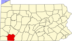
 Location of Fayette County in Pennsylvania | |
| Country | United States |
| State | Pennsylvania |
| County | Fayette |
| Established | 1824-06-09 |
| Area | |
• Total | 53.05 sq mi (137.41 km2) |
| • Land | 51.24 sq mi (132.72 km2) |
| • Water | 1.81 sq mi (4.69 km2) |
| Population | |
• Total | 1,764 |
• Estimate (2022)[2] | 1,714 |
| • Density | 39.21/sq mi (15.14/km2) |
| Time zone | UTC-4 (EST) |
| • Summer (DST) | UTC-5 (EDT) |
| Area code | 724 |
Henry Clay Township is a township in Fayette County, Pennsylvania, United States. The population was 1,764 at the 2020 census.[2] The township was created June 9, 1824, from the eastern portion of Wharton Township. It is named for 19th-century American statesman Henry Clay. The northwestern corner of its territory was used to create Stewart Township on November 17, 1855. It is served by the Uniontown Area School District.
Unincorporated communities located within the township include Flat Rock, Fiketown, and Elk Park.
Information can be sourced at www.henryclaytownship.com
- ^ "2016 U.S. Gazetteer Files". United States Census Bureau. Retrieved August 13, 2017.
- ^ a b c Bureau, US Census. "City and Town Population Totals: 2020-2022". Census.gov. US Census Bureau. Retrieved December 1, 2023.
{{cite web}}:|last1=has generic name (help)