Hepburn Township, Pennsylvania | |
|---|---|
 Blooming Grove Dunkard Church, built ca. 1805 | |
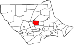
 Map of Lycoming County, Pennsylvania highlighting Hepburn Township | |
 Map of Lycoming County, Pennsylvania | |
| Coordinates: 41°18′53″N 77°2′34″W / 41.31472°N 77.04278°W | |
| Country | United States |
| State | Pennsylvania |
| County | Lycoming |
| Settled | 1784 |
| Formed | 1804 |
| Government | |
| • Type | Board of Supervisors |
| • Chairman | Joseph Hamm |
| • Vice-chairman | Robert Fesemyer Jr. |
| • Supervisor | Oscar Schon |
| Area | |
| • Total | 16.77 sq mi (43.42 km2) |
| • Land | 16.67 sq mi (43.17 km2) |
| • Water | 0.10 sq mi (0.25 km2) |
| Elevation | 906 ft (276 m) |
| Population | |
| • Total | 2,579 |
| • Estimate (2021)[2] | 2,563 |
| • Density | 163.19/sq mi (63.01/km2) |
| Time zone | UTC-5 (Eastern Time Zone (North America)) |
| • Summer (DST) | UTC-4 (EDT) |
| ZIP code | 17728 |
| Area code | 570 |
| FIPS code | 42-081-33944 |
| GNIS feature ID | 1216751[3] |
| Website | www |
Hepburn Township is a township in Lycoming County, Pennsylvania, United States. The population was 2,579 at the 2020 census.[2] It is part of the Williamsport Metropolitan Statistical Area.
- ^ "2016 U.S. Gazetteer Files". United States Census Bureau. Retrieved August 14, 2017.
- ^ a b c Bureau, US Census. "City and Town Population Totals: 2020-2021". Census.gov. US Census Bureau. Retrieved July 15, 2022.
{{cite web}}:|last1=has generic name (help) - ^ "US Board on Geographic Names". United States Geological Survey. October 25, 2007. Retrieved January 31, 2008.