Heredia | |
|---|---|
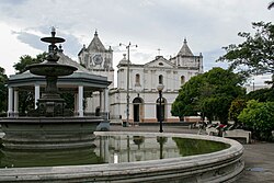
 Inmaculada Concepción Church, Heredia | |
 Heredia canton | |
| Coordinates: 10°07′44″N 84°02′31″W / 10.1289028°N 84.0419806°W | |
| Country | |
| Province | Heredia |
| Creation | 7 December 1848 |
| Head city | Heredia |
| Districts | |
| Government | |
| • Type | Municipality |
| • Body | Municipalidad de Heredia |
| • Mayor | Ángela Ileana Aguilar Vargas (PLN) |
| Area | |
• Total | 282.6 km2 (109.1 sq mi) |
| Elevation | 1,242 m (4,075 ft) |
| Population (2011) | |
• Total | 123,616 |
• Estimate (2022) | 131,901 |
| • Density | 440/km2 (1,100/sq mi) |
| Time zone | UTC−06:00 |
| Canton code | 401 |
| Website | www |
You can help expand this article with text translated from the corresponding article in Spanish. (July 2024) Click [show] for important translation instructions.
|
Heredia is a canton in the Heredia province of Costa Rica.[1][2] The head city is in Heredia district, and is also the provincial capital of Heredia Province.
- ^ "Declara oficial para efectos administrativos, la aprobación de la División Territorial Administrativa de la República N°41548-MGP". Sistema Costarricense de Información Jurídica (in Spanish). 19 March 2019. Archived from the original on 24 February 2024. Retrieved 26 September 2020.
- ^ División Territorial Administrativa de la República de Costa Rica (PDF) (in Spanish). Editorial Digital de la Imprenta Nacional. 8 March 2017. ISBN 978-9977-58-477-5.


