Herefoss Municipality
Herefoss herred | |
|---|---|
| Hegrefoss herred (historic name) | |
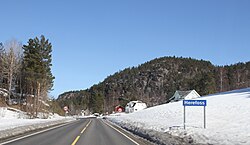
 View of the village of Herefoss | |
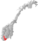
 Aust-Agder within Norway | |
 Herefoss within Aust-Agder | |
| Coordinates: 58°31′27″N 8°21′04″E / 58.5243°N 08.3511°E | |
| Country | Norway |
| County | Aust-Agder |
| Established | 1 Jan 1838 |
| • Created as | Formannskapsdistrikt |
| Disestablished | 1 Jan 1967 |
| • Succeeded by | Birkenes Municipality |
| Administrative centre | Herefoss |
| Area (upon dissolution) | |
| • Total | 148 km2 (57 sq mi) |
| Population (1967) | |
| • Total | 585 |
| • Density | 4.0/km2 (10/sq mi) |
| Time zone | UTC+01:00 (CET) |
| • Summer (DST) | UTC+02:00 (CEST) |
| ISO 3166 code | NO-0933[1] |
Herefoss is a former municipality in the old Aust-Agder county in Norway. The municipality existed from 1838 until its dissolution in 1967 when it was merged into Birkenes municipality in what is now Agder county. Herefoss was a 148-square-kilometre (57 sq mi) area surrounding the Herefossfjorden (part of the river Tovdalselva). The administrative centre was the village of Herefoss where the Herefoss Church is located. The other main village was Søre Herefoss, located in the southern part of the municipality.[2]
- ^ Bolstad, Erik; Thorsnæs, Geir, eds. (26 January 2023). "Kommunenummer". Store norske leksikon (in Norwegian). Kunnskapsforlaget.
- ^ Thorsnæs, Geir, ed. (29 January 2016). "Herefoss". Store norske leksikon (in Norwegian). Kunnskapsforlaget. Retrieved 8 June 2017.