Herekino | |
|---|---|
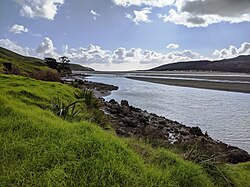
 Herekino Harbour near Owhata | |
 | |
| Coordinates: 35°15′53″S 173°12′38″E / 35.26472°S 173.21056°E | |
| Country | New Zealand |
| Region | Northland Region |
| District | Far North District |
| Ward | Te Hiku |
| Community | Te Hiku |
| Subdivision | Kaitāia |
| Electorates | |
| Government | |
| • Territorial Authority | Far North District Council |
| • Regional council | Northland Regional Council |
| Area | |
| • Total | 11.47 km2 (4.43 sq mi) |
| Population (2018)[2] | |
| • Total | 84 |
| • Density | 7.3/km2 (19/sq mi) |
Herekino is a locality in Northland, New Zealand. It lies 26 km south west of Kaitaia. The Herekino Harbour, also called the Herekino River, is an estuary and inlet from the Tasman Sea to the west. The Herekino Forest, which contains a stand of large kauri, is to the north, and the Tauroa Peninsula lies to the north west.[3]
The harbour is mostly above water at high tide, with just a shallow entrance channel. The upper reaches of the harbour contain a mangrove forest.[4] The township of Herekino is at the north east end of the estuary, and the small settlement of Owhata lies on the rocky south shore of the harbour entrance. Owhata is a flat grassy area, with a fairly shallow beach of mud and sand. There is not much natural shelter, and there is a limited supply of fresh water in summer.[5]
- ^ Cite error: The named reference
Areawas invoked but never defined (see the help page). - ^ Cite error: The named reference
Census 2018was invoked but never defined (see the help page). - ^ "Kaitāia and district". Te Ara: The Encyclopedia of New Zealand.
- ^ "Description of Area: Hokianga, Whangape and Herekino Harbours". Northland Marine Library. Archived from the original on 21 October 2008. Retrieved 15 January 2008.
- ^ Parkes, W. F. (c. 1965). The Visitors' Guide to the Far North – Mangonui County (3rd ed.). p. 14.