This article needs additional citations for verification. (December 2009) |
Hermsdorf | |
|---|---|
 Village church | |
| Coordinates: 52°37′00″N 13°19′00″E / 52.61667°N 13.31667°E | |
| Country | Germany |
| State | Berlin |
| City | Berlin |
| Borough | Reinickendorf |
| Founded | 1200 |
| Area | |
• Total | 6.1 km2 (2.4 sq mi) |
| Highest elevation | 65 m (213 ft) |
| Lowest elevation | 30 m (100 ft) |
| Population (2023-12-31)[1] | |
• Total | 16,611 |
| • Density | 2,700/km2 (7,100/sq mi) |
| Time zone | UTC+01:00 (CET) |
| • Summer (DST) | UTC+02:00 (CEST) |
| Postal codes | 13467 |
| Vehicle registration | B |
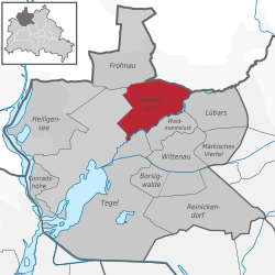
Hermsdorf (German pronunciation: [ˈhɛʁmsˌdɔʁf] ) is a district (Ortsteil) of Berlin located in the borough (Bezirk) of Reinickendorf.


