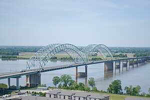
Hernando de Soto Bridge | |
|---|---|
 Hernando de Soto Bridge photographed from the Memphis Pyramid | |
| Coordinates | 35°09′10″N 90°03′50″W / 35.15278°N 90.06389°W |
| Carries | 6 lanes of |
| Crosses | Mississippi River |
| Locale | Memphis, Tennessee, and West Memphis, Arkansas |
| Other name(s) | The M Bridge, Memphis Bridge, Mississippi Bridge, New Bridge |
| Maintained by | TDOT and ARDOT |
| ID number | 79I00400001 |
| Characteristics | |
| Design | tied arch, through arch |
| Material | Steel |
| Pier construction | Concrete |
| Total length | 9,432.6 feet (2,875 m) |
| Width | 90 feet (27 m) |
| Longest span | 900 feet (274 m) |
| Clearance below | 109 feet (33 m) |
| History | |
| Construction start | May 2, 1967 |
| Opened | August 2, 1973 |
| Statistics | |
| Daily traffic | 37,308 (2018)[1] |
| Location | |
 | |
The Hernando de Soto Bridge is a tied-arch bridge carrying Interstate 40 across the Mississippi River between West Memphis, Arkansas, and Memphis, Tennessee. The design is a continuous cantilevered cable-stayed steel through arch, with bedstead endposts. Memphians also call the bridge the "New Bridge",[2] as it is newer than the Memphis & Arkansas Bridge (carrying Interstate 55) downstream, and the "M Bridge", due to its distinctive shape. It is of similar construction to the Sherman Minton Bridge between Louisville, Kentucky, and New Albany, Indiana (except that it consists of a single level deck).
- ^ Tennessee Department of Transportation. "Traffic History". ArcGIS. Esri. Retrieved July 18, 2020.
- ^ Teresa R. Simpson (February 17, 2008). "About.com:Memphis:The Mississippi River". About.com. Archived from the original on November 18, 2008. Retrieved November 11, 2008.