Herne Bay | |
|---|---|
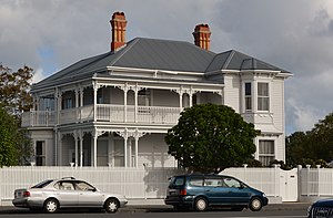
 A large wooden house on Jervois Road, in a style typical of Herne Bay. | |
 | |
| Coordinates: 36°51′S 174°44′E / 36.850°S 174.733°E | |
| Country | New Zealand |
| City | Auckland |
| Local authority | Auckland Council |
| Electoral ward | Waitematā and Gulf ward |
| Local board | Waitematā Local Board |
| Area | |
| • Land | 88 ha (217 acres) |
| Population (June 2023)[2] | |
| • Total | 2,820 |
| Waitematā Harbour | Waitematā Harbour | |
| Westmere, Coxs Bay |
|
Saint Marys Bay |
| Coxs Bay | Ponsonby, Grey Lynn |
Herne Bay /hɜːrn/ is an affluent suburb of Auckland, New Zealand. It is located on the southwestern shore of the Waitematā Harbour to the west of the Auckland Harbour Bridge. It is known for its extensive harbour views, marine villas and Edwardian age homes. Herne Bay has been a prosperous area since the 1850s due to its outlook over the Waitemata Harbour. It continues to be an exclusive suburb, as it ranked as the most expensive suburb in New Zealand in 2015.[3] In 2021 it again topped rankings of the most expensive suburbs in New Zealand, with a median property value of $3.25 million. [4]
Herne Bay is under the local governance of Auckland Council.
- ^ Cite error: The named reference
Areawas invoked but never defined (see the help page). - ^ "Population estimate tables - NZ.Stat". Statistics New Zealand. Retrieved 25 October 2023.
- ^ "Herne Bay is New Zealand's first $2 million suburb". The New Zealand Herald. 11 June 2015. ISSN 1170-0777. Retrieved 4 January 2017.
- ^ "Find out how much house prices rose in your suburb last year with this fun* tool". The Spinoff. 28 September 2021. Retrieved 28 September 2021.