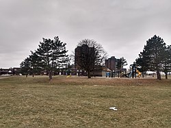
Heron Gate | |
|---|---|
Neighbourhood | |
 Sandalwood Park | |
| Coordinates: 45°22′40″N 75°39′00″W / 45.37778°N 75.65000°W | |
| Country | Canada |
| Province | Ontario |
| City | Ottawa |
| Government | |
| • MPs | David McGuinty |
| • MPPs | John Fraser |
| • Councillors | Marty Carr, Jessica Bradley |
| • Community association | Herongate Tenant Coalition |
| Area | |
| • Total | 1.538 km2 (0.594 sq mi) |
| Elevation | 90 m (300 ft) |
| Population (2021) | |
| • Total | 9,974 |
| • Density | 6,458/km2 (16,730/sq mi) |
| Canada 2021 Census | |
| Time zone | UTC-5 (Eastern (EST)) |
Heron Gate[1] or Herongate is a neighbourhood in Alta Vista Ward and Gloucester-Southgate Ward in the south end of Ottawa, Ontario, Canada. It is defined by the Herongate Tenant Coalition as being bounded on the north by Heron Road, on the west by Heron-Walkley Park and Albion Road, and by the Walkley rail corridor on the south.[2] The total population for this area (excluding the Oak apartments on Albion which are in a different Census block) according to the Canada 2021 Census was 9,974.[3]
There are several parks in the neighbourhood, and is served by Ridgemont High School), St. Patrick's High School, St. Patrick Intermediate and Charles Hulse Elementary School for education. The area has train tracks to the south. It is one of the most densely populated neighbourhoods in the city. A number of new developments were completed on the west of the neighbourhood between 2006 and 2008.
- ^ "Place names - Heron Gate".
- ^ "Our Neighbourhood – #DefendHerongate".
- ^ Population calculated by combining the populations of Census Tract 5050007.02 with Dissemination Areas 35061282, 35060895, 35061319, 35061320, 35060893
