Hersonissos
Χερσόνησος Chersónisos | |
|---|---|
 View of the city. | |
| Coordinates: 35°19′N 25°23.4′E / 35.317°N 25.3900°E | |
| Country | Greece |
| Administrative region | Crete |
| Regional unit | Heraklion |
| Area | |
| • Municipality | 272.2 km2 (105.1 sq mi) |
| • Municipal unit | 71.0 km2 (27.4 sq mi) |
| Elevation | 28 m (92 ft) |
| Population (2021)[1] | |
| • Municipality | 27,220 |
| • Density | 100/km2 (260/sq mi) |
| • Municipal unit | 7,333 |
| • Municipal unit density | 100/km2 (270/sq mi) |
| • Community | 2,985 |
| Time zone | UTC+2 (EET) |
| • Summer (DST) | UTC+3 (EEST) |
| Website | www.hersonissos.gr |
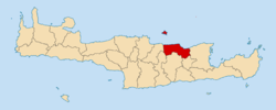
Hersonissos (Greek: Χερσόνησος, meaning “peninsula”, Chersónisos, pronounced [xerˈsonisos]), also transliterated as Chersonissos and Hersónisos, is a town and a local government unit in the north of Crete, bordering the Mediterranean / Aegean Sea. The town is about 25 kilometers east of Heraklion and west of Agios Nikolaos. What is usually called Hersonissos is in fact its peninsula and harbour. It is part of the Heraklion regional unit. It is situated 25 km from the Heraklion airport and 27 km from the Heraklion port. The seat of the local government unit is the village of Gournes.[2]
- ^ "Αποτελέσματα Απογραφής Πληθυσμού - Κατοικιών 2021, Μόνιμος Πληθυσμός κατά οικισμό" [Results of the 2021 Population - Housing Census, Permanent population by settlement] (in Greek). Hellenic Statistical Authority. 29 March 2024.
- ^ "ΦΕΚ A 87/2010, Kallikratis reform law text" (in Greek). Government Gazette.

