Heuvelland | |
|---|---|
 | |
| Coordinates: 50°46′N 02°49′E / 50.767°N 2.817°E | |
| Country | |
| Community | Flemish Community |
| Region | Flemish Region |
| Province | West Flanders |
| Arrondissement | Ypres |
| Government | |
| • Mayor | Wieland De Meyer (GB) |
| • Governing party/ies | Gemeentebelangen (GB) |
| Area | |
• Total | 94.79 km2 (36.60 sq mi) |
| Population (2018-01-01)[1] | |
• Total | 7,862 |
| • Density | 83/km2 (210/sq mi) |
| Postal codes | 8950-8954, 8956, 8958 |
| NIS code | 33039 |
| Area codes | 057 |
| Website | www.heuvelland.be |
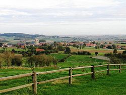
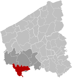
Heuvelland (Dutch pronunciation: [ˈɦøːvəlɑnt] ) is a municipality located in the Belgian province of West Flanders. The municipality comprises the villages of Dranouter, Kemmel, De Klijte, Loker, Nieuwkerke, Westouter, Wijtschate and Wulvergem. Heuvelland is a thinly populated rural municipality, located between the small urban centres of Ypres and Poperinge and the metropolitan area of Kortrijk-Lille along the E17. On 1 January 2006 Heuvelland had a total population of 8,217. The total area is 94.24 km2 which gives a population density of 87 inhabitants per km2. The name heuvelland is Dutch meaning "hill country", as the municipality is characterized by the different hills on its territory.
- ^ "Wettelijke Bevolking per gemeente op 1 januari 2018". Statbel. Retrieved 9 March 2019.


