Hewanorra International Airport Aéroport International Hewanorra | |||||||||||
|---|---|---|---|---|---|---|---|---|---|---|---|
 | |||||||||||
| Summary | |||||||||||
| Airport type | Public | ||||||||||
| Owner | Government of Saint Lucia | ||||||||||
| Operator | Saint Lucia Air and Seaports Authority | ||||||||||
| Serves | Vieux Fort, Saint Lucia | ||||||||||
| Location | La Tourney, Vieux Fort | ||||||||||
| Opened | 1941 | ||||||||||
| Hub for | Saint Lucia Helicopters | ||||||||||
| Time zone | AST (UTC−04:00) | ||||||||||
| Elevation AMSL | 14 ft / 4 m | ||||||||||
| Coordinates | 13°44′00″N 060°57′09″W / 13.73333°N 60.95250°W | ||||||||||
| Website | www | ||||||||||
| Map | |||||||||||
 | |||||||||||
| Runways | |||||||||||
| |||||||||||
| Helipads | |||||||||||
| |||||||||||
| Statistics (2019 Q1) | |||||||||||
| |||||||||||
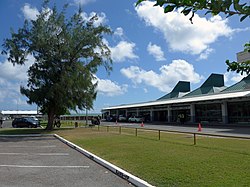
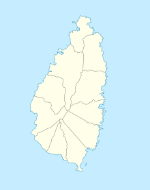
Hewanorra International Airport (IATA: UVF, ICAO: TLPL), located near Vieux Fort Quarter, Saint Lucia, in the Caribbean, is the larger of Saint Lucia's two airports and is managed by the Saint Lucia Air and Seaports Authority (SLASPA). It is on the southern cape of the island, about 53.4 km (33.2 mi) from the capital city, Castries.
The airport is a Fire Category 9 facility that handles 700,000 passengers a year and can accommodate Boeing 747, Airbus A330, Airbus A340, Boeing 777 and other long-range intercontinental jet aircraft. Aircraft maintenance is carried out by Caribbean Dispatch Services. The country's smaller airport, George F. L. Charles Airport, is located in the capital city of Castries and handles inter-Caribbean passenger flights, which are currently operated with regional turboprop aircraft as well as with smaller prop aircraft.
- ^ "Airport information for TLPL". World Aero Data. Archived from the original on 14 October 2007. Retrieved 16 January 2023.
{{cite web}}: CS1 maint: unfit URL (link) Data current as of October 2007. Source: DAFIF.
