| High Schells Wilderness | |
|---|---|
 | |
| Location | White Pine County, Nevada United States |
| Nearest city | Ely, Nevada |
| Coordinates | 39°20′24″N 114°35′57″W / 39.3399041581°N 114.599215912°W[2] |
| Area | 121,497 acres (49,168 ha) |
| Established | December 20, 2006 |
| Governing body | U.S. Forest Service |
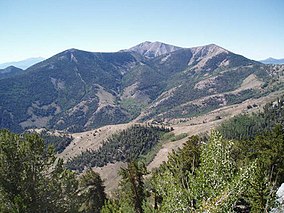
The High Schells Wilderness is a 121,497-acre (49,168 ha) wilderness area in the Schell Creek Range of White Pine County, in the U.S. state of Nevada. The Wilderness lies within the Humboldt-Toiyabe National Forest and is therefore administered by the U.S. Forest Service.[3]
- ^ Protected Area Profile for High Schells Wilderness from the World Database on Protected Areas. Retrieved May 2 2023.
- ^ "High Schells Wilderness Map". Wilderness.net. Retrieved 2011-08-19.
- ^ Humboldt-Toiyabe National Forest - High Schells Wilderness

