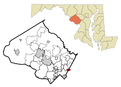
Hillandale, Maryland | |
|---|---|
 Location of Hillandale, Maryland | |
| Coordinates: 39°01′30″N 76°58′25″W / 39.02500°N 76.97361°W | |
| Country | |
| State | |
| Counties | |
| Area | |
| • Total | 1.89 sq mi (4.89 km2) |
| • Land | 1.89 sq mi (4.89 km2) |
| • Water | 0.00 sq mi (0.00 km2) |
| Elevation | 246 ft (75 m) |
| Population (2020) | |
| • Total | 5,774 |
| • Density | 3,056.64/sq mi (1,180.17/km2) |
| Time zone | UTC-5 (Eastern (EST)) |
| • Summer (DST) | UTC-4 (EDT) |
| ZIP code | 20903 |
| Area code(s) | 301, 240 |
| FIPS code | 24-38850 |
| GNIS feature ID | 2389929[2] |
Hillandale is an unincorporated area and census-designated place located in Montgomery and Prince George's counties, Maryland, United States. As of the 2020 census, it had a population of 5,774.[3][4] Hillandale is contained between the Prince George's / Montgomery County line to the east, the Anacostia River to the west, McCeney Avenue to the north, and D.C.'s Capital Beltway to the south. It borders the communities of Adelphi, Avenel, White Oak and Beltsville.
- ^ "2020 U.S. Gazetteer Files". United States Census Bureau. Retrieved April 26, 2022.
- ^ a b U.S. Geological Survey Geographic Names Information System: Hillandale, Maryland
- ^ "QuickFacts: Hillandale CDP, Maryland". United States Census Bureau. Retrieved August 17, 2021.
- ^ "Hillandale CDP, Maryland". United States Census Bureau. Retrieved April 15, 2022.