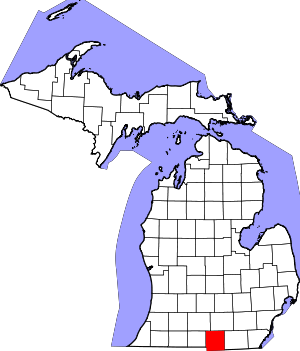
Hillsdale County | |
|---|---|
 | |
 Location within the U.S. state of Michigan | |
 Michigan's location within the U.S. | |
| Coordinates: 41°53′N 84°35′W / 41.89°N 84.59°W | |
| Country | |
| State | |
| Founded | 1835[1] |
| Seat | Hillsdale |
| Largest city | Hillsdale |
| Area | |
• Total | 607 sq mi (1,570 km2) |
| • Land | 598 sq mi (1,550 km2) |
| • Water | 8.9 sq mi (23 km2) 1.5% |
| Population (2020) | |
• Total | 45,746 |
| • Density | 75/sq mi (29/km2) |
| Time zone | UTC−5 (Eastern) |
| • Summer (DST) | UTC−4 (EDT) |
| Congressional district | 5th |
| Website | https://www.co.hillsdale.mi.us/ |
Hillsdale County is a county located in the U.S. state of Michigan. As of the 2020 Census, the population was 45,746.[2] The county seat is Hillsdale.[3] Hillsdale County is the only county in Michigan to border both Indiana and Ohio. Due to an angle in the state's border with Ohio, Hillsdale County has the southernmost point in Michigan. Hillsdale County is conterminous with the Hillsdale, MI Micropolitan Statistical Area. The Hillsdale County Courthouse was designed by Claire Allen, a prominent southern Michigan architect.
- ^ Cite error: The named reference
clarkewas invoked but never defined (see the help page). - ^ "State & County QuickFacts". US Census Bureau. Retrieved September 15, 2021.
- ^ "Find a County". National Association of Counties. Archived from the original on May 31, 2011. Retrieved July 7, 2011.