Hinckley
Gaa-zhiigwanaabikokaag | |
|---|---|
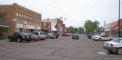
 Main Street in downtown Hinckley in 2007 | |
 Location of the city of Hinckley within Pine County, Minnesota | |
| Coordinates: 46°0′44″N 92°56′32″W / 46.01222°N 92.94222°W | |
| Country | United States |
| State | Minnesota |
| County | Pine |
| Incorporated (village) | 1885[1] |
| Incorporated (city) | November 27, 1907[1] |
| Government | |
| • Mayor | Donald Zeman[2] |
| Area | |
| • Total | 3.84 sq mi (9.93 km2) |
| • Land | 3.79 sq mi (9.81 km2) |
| • Water | 0.05 sq mi (0.13 km2) |
| Elevation | 1,014 ft (309 m) |
| Population (2020) | |
| • Total | 1,904 |
| • Density | 502.91/sq mi (194.18/km2) |
| • Demonym | Hincklian |
| Time zone | UTC-6 (Central (CST)) |
| • Summer (DST) | UTC-5 (CDT) |
| ZIP code | 55037 |
| Area code | 320 |
| FIPS code | 27-29294[5] |
| GNIS feature ID | 2394390[4] |
| Website | www.hinckley.govoffice2.com |
Hinckley is a city in Pine County, Minnesota, United States, located at the junction of Interstate 35 and Minnesota State Highway 48. The population was 1,800 at the 2010 census.[6]
Hinckley's name in the Ojibwe language is Gaa-zhiigwanaabikokaag,[7][8] meaning "the place abundant with grindstones" due to being located along the Grindstone River. Portions of the Mille Lacs Indian Reservation are located within and adjacent to Hinckley.
On September 1, 1894, the Great Hinckley Fire killed more than 400 people.
Hinckley is generally considered the halfway point on Interstate 35 between Minneapolis–Saint Paul and Duluth.
- ^ a b "Guide to Hinckley Minnesota". www.lakesnwoods.com. Retrieved April 23, 2018.
- ^ "City Officials - Pine County Minnesota". www.co.pine.mn.us. Archived from the original on March 4, 2018. Retrieved April 23, 2018.
- ^ "2020 U.S. Gazetteer Files". United States Census Bureau. Retrieved July 24, 2022.
- ^ a b U.S. Geological Survey Geographic Names Information System: Hinckley, Minnesota
- ^ "U.S. Census website". United States Census Bureau. Retrieved January 31, 2008.
- ^ "2010 Census Redistricting Data (Public Law 94-171) Summary File". American FactFinder. U.S. Census Bureau, 2010 Census. Retrieved April 23, 2011.[dead link]
- ^ "Mille Lacs Band Statutes, Annotated (2MLBSA§11c)" (PDF). Archived from the original (PDF) on September 9, 2008. Retrieved July 3, 2008.
- ^ Weshki-ayaad, Lippert and Gambill. Freelang Ojibwe Dictionary
