Hingan League
兴安盟 ᠬᠢᠩᠭ᠋ᠠᠨ ᠠᠶᠢᠮᠠᠭ | |
|---|---|
 Arxan, Hingan | |
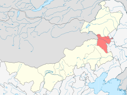
 Location of Hingan League in Inner Mongolia | |
| Coordinates (Ulanhot): 46°04′N 122°05′E / 46.07°N 122.09°E | |
| Country | China |
| Region | Inner Mongolia |
| League Seat of Government | Ulanhot |
| Area | |
• Total | 59,806 km2 (23,091 sq mi) |
| Population (2010) | |
• Total | 1,613,250 |
| • Density | 27/km2 (70/sq mi) |
| GDP[1] | |
| • Total | CN¥ 50.2 billion US$ 8.1 billion |
| • Per capita | CN¥ 31,391 US$ 5,040 |
| Time zone | UTC+8 (China Standard) |
| ISO 3166 code | CN-NM-22 |
| Website | xam.gov.cn |
| Hinggan League | |||||||
|---|---|---|---|---|---|---|---|
| Chinese name | |||||||
| Traditional Chinese | 興安盟 | ||||||
| Simplified Chinese | 兴安盟 | ||||||
| |||||||
| Mongolian name | |||||||
| Mongolian Cyrillic | Хянган аймаг | ||||||
| Mongolian script | ᠬᠢᠩᠭ᠋ᠠᠨ ᠠᠢᠮᠠᠭ | ||||||
| |||||||
The Hinggan League[a] is a prefecture-level subdivision of the Inner Mongolia Autonomous Region of the People's Republic of China. It borders Hulun Buir to the north, the Republic of Mongolia and Xilingol League to the west, Tongliao to the south and the provinces of Jilin and Heilongjiang to the east. The name is derived from the Greater Khingan mountain range that crosses the league from the northwest to the southeast.
- ^ 内蒙古自治区统计局、国家统计局内蒙古调查总队 (2016). 《内蒙古统计年鉴-2016》. 中国统计出版社. ISBN 978-7-5037-7901-5.
Cite error: There are <ref group=lower-alpha> tags or {{efn}} templates on this page, but the references will not show without a {{reflist|group=lower-alpha}} template or {{notelist}} template (see the help page).