This article needs additional citations for verification. (July 2013) |
Hinunangan | |
|---|---|
| Municipality of Hinunangan | |
 Aerial view of Hinunangan | |
| Motto: Rice Granary of Southern Leyte | |
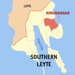
 Map of Southern Leyte with Hinunangan highlighted | |
Location within the Philippines | |
| Coordinates: 10°24′N 125°12′E / 10.4°N 125.2°E | |
| Country | Philippines |
| Region | Eastern Visayas |
| Province | Southern Leyte |
| District | 2nd district |
| Barangays | 40 (see Barangays) |
| Government | |
| • Type | Sangguniang Bayan |
| • Mayor | Reynaldo C. Fernandez (PDPLBN) |
| • Vice Mayor | Marian D. Pelin (PDPLBN) |
| • Representative | Christopherson M. Yap |
| • Municipal Council | Members |
| • Electorate | 21,548 voters (2022) |
| Area | |
• Total | 170.58 km2 (65.86 sq mi) |
| Elevation | 4.8 m (15.7 ft) |
| Highest elevation | 401 m (1,316 ft) |
| Lowest elevation | −1 m (−3 ft) |
| Population (2020 census)[4] | |
• Total | 29,149 |
| • Density | 170/km2 (440/sq mi) |
| • Households | 7,402 |
| Economy | |
| • Income class | 3rd municipal income class |
| • Poverty incidence | 21.94 |
| • Revenue | ₱ 138.2 million (2020), 62.2 million (2012), 67.45 million (2013), 80.64 million (2014), 87.71 million (2015), 103.6 million (2016), 5.857 million (2017), 8.295 million (2018), 126.4 million (2019), 151.9 million (2021), 195.4 million (2022) |
| • Assets | ₱ 254 million (2020), 149.5 million (2012), 1.471 million (2013), 123.3 million (2014), 114.7 million (2015), 144.1 million (2016), 198.2 million (2017), 235.2 million (2018), 320.1 million (2021), 380.6 million (2022) |
| • Expenditure | ₱ 136 million (2020), 102.1 million (2012), 64.27 million (2013), 72.63 million (2014), 82.84 million (2015), 80.27 million (2016), 82.65 million (2017), 86.96 million (2018), 114.7 million (2019), 130.1 million (2021), 158 million (2022) |
| • Liabilities | ₱ 97.01 million (2020), 83.19 million (2012), 65.36 million (2013), 61.39 million (2014), 70.71 million (2015), 66.57 million (2016), 81.81 million (2017), 85.06 million (2018), 91.65 million (2019), 127.5 million (2021), 125.4 million (2022) |
| Service provider | |
| • Electricity | Southern Leyte Electric Cooperative (SOLECO) |
| Time zone | UTC+8 (PST) |
| ZIP code | 6608 |
| PSGC | |
| IDD : area code | +63 (0)53 |
| Native languages | Boholano dialect Cebuano Tagalog |
Hinunangan, officially the Municipality of Hinunangan (Kabalian: Lungsod san Hinunangan; Cebuano: Lungsod sa Hinunangan; Tagalog: Bayan ng Hinunangan), is a 3rd class municipality in the province of Southern Leyte, Philippines. According to the 2020 census, it has a population of 29,149 people.[4]
Hinunangan is known as the "Rice Granary of the Province" for its vast plain land that is entirely planted with rice. Hinunangan has great potential for tourism because of its beautiful sandy beaches and islands. The town is also a producer of rattan and wood-based furniture, abaca handicraft items, pineapple, vegetables, other forest products, and bamboo furniture. It has a potential for mineral water and root crop processing and copper mining.[6]
Hinunangan is also known as a major gateway in Leyte because of its near proximity to Tacloban City. The opening of Abuyog–Silago Road cuts travel time from Tacloban by half from the previous 6 hours to less than 3 hours. It is also the place in Southern Leyte with the most immigrants from Europe and North America.
It has a lot of tourist places, such as Tahusan, Talisay, or the twin islands (known as Cabugan Grande and Cabugan Chico as Pigafetta stated in his account during their travel with Magellan).[citation needed]. There are also hotels, inns, a public market, and beach resorts.
- ^ Municipality of Hinunangan | (DILG)
- ^ "2015 Census of Population, Report No. 3 – Population, Land Area, and Population Density" (PDF). Philippine Statistics Authority. Quezon City, Philippines. August 2016. ISSN 0117-1453. Archived (PDF) from the original on May 25, 2021. Retrieved July 16, 2021.
- ^ https://www.philatlas.com/visayas/r08/southern-leyte/hinunangan.html.
{{cite web}}: Missing or empty|title=(help) - ^ a b Census of Population (2020). "Region VIII (Eastern Visayas)". Total Population by Province, City, Municipality and Barangay. Philippine Statistics Authority. Retrieved 8 July 2021.
- ^ "PSA Releases the 2021 City and Municipal Level Poverty Estimates". Philippine Statistics Authority. 2 April 2024. Retrieved 28 April 2024.
- ^ "Local Government Unit". Archived from the original on 2006-05-21. Retrieved 2008-11-05., Southern Leyte LGU website


