Hutin
حطّين Hattin, Hittan | |
|---|---|
 Hittin, 1934 | |
| Etymology: from personal name[1] | |
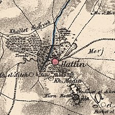
A series of historical maps of the area around Hittin (click the buttons) | |
Location within Mandatory Palestine | |
| Coordinates: 32°48′25″N 35°27′12″E / 32.80694°N 35.45333°E | |
| Palestine grid | 192/245 |
| Geopolitical entity | Mandatory Palestine |
| Subdistrict | Tiberias |
| Date of depopulation | 16–17 July 1948[4] |
| Area | |
• Total | 22,764 dunams (22.764 km2 or 8.789 sq mi) |
| Population (1945) | |
• Total | 1,190[2][3] |
| Cause(s) of depopulation | Fear of being caught up in the fighting |
| Secondary cause | Military assault by Yishuv forces |
| Current Localities | Arbel, Kefar Zetim |
Hittin (Arabic: حطّين, transliterated Ḥiṭṭīn (Arabic: حِـطِّـيْـن) or Ḥaṭṭīn (Arabic: حَـطِّـيْـن)) was a Palestinian village located 8 kilometers (5 mi) west of Tiberias before it was occupied by Israel during the 1948 Arab-Israeli war when most of its original residents became refugees. As the site of the Battle of Hattin in 1187, in which Saladin reconquered most of Palestine from the Crusaders, it has become an Arab nationalist symbol. The shrine of Nabi Shu'ayb, venerated by the Druze and Sunni Muslims as the tomb of Jethro, is on the village land. The village was ruled by the Ottoman Empire from the 16th century until the end of World War I, when Palestine became part of the British Mandate for Palestine. On July 17 1948, the village was occupied by Israel during the nakbaa, after its residents fled out of their homes because of Nazareth's occupation. in later years, the Moshavs Arbel and Kfar Zeitim were erected where Hittin used to be.


