Hoeven | |
|---|---|
Village | |
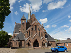
 St John the Baptist Church | |
| Coordinates: 51°34′39″N 4°34′51″E / 51.57750°N 4.58083°E | |
| Country | Netherlands |
| Province | North Brabant |
| Municipality | Halderberge |
| Area | |
| • Total | 24.80 km2 (9.58 sq mi) |
| Elevation | 4.0 m (13.1 ft) |
| Population (2021)[1] | |
| • Total | 6,680 |
| • Density | 270/km2 (700/sq mi) |
| Time zone | UTC+1 (CET) |
| • Summer (DST) | UTC+2 (CEST) |
| Postal code | 4741[1] |
| Dialing code | 0165 |
Hoeven is a village in the municipality of Halderberge in the Netherlands. The name Hoeven originated from the purchase of a certain amount of ground in 1282 by the abbey of Cistercians of St. Bernard. This amount was equal to 100 "hoeven", a local measure of area in those days. A hoeve is approximately 12 bunder. A "bunder" equals the area of the average agricultural farm in the Netherlands.
- ^ a b c "Kerncijfers wijken en buurten 2021". Central Bureau of Statistics. Retrieved 16 April 2022.
- ^ "Postcodetool for 4741AA". Actueel Hoogtebestand Nederland (in Dutch). Het Waterschapshuis. Retrieved 16 April 2022.

